 |
|
|
 |
Joined: 27/08/2013
Posts: 1
|
|
|
Although some of the arguments blaming the flight crew for this accident sound convincing on the surface, whenever I review either Vette's or Mahon's writings it seems that they are entirely justified for their conclusions. Most of the counter arguments do not seem to address the evidence in its totality. Some of the most disturbing is Captain Keesing's testimony as the ANZ Flight Operations Director up until April 1979, stating that in fact it WAS ANZ company policy to fly below 2000 feet, that that was always the policy AND practice of ANZ, and that Ian Gemmel's correspondence with the Civil Aviation Dept regarding 6000 and 16000 foot MSA's was without his knowledge, furthermore that CAD's letter confirming these altitudes was only received by ANZ one week AFTER the fatal accident, and when the previous arrangement had been to fly well below these altitudes.
Mahon was to refer to this timing somewhat charitably as "unfortunate". Keesing was the only then current or former senior person from ANZ who admitted seeing and authorizing one of the MANY well publicized articles indicating clearly that the flights were ALWAYS carried out well below 6000 feet, with the possible exception of the first two, when passengers in fact complained about the poor viewing at high level. Search Youtube and you will find footage filmed by the National Film Unit on the flight previous to the fatal one with the pilot clearly announcing the altitude as 3000 feet, so much for the argument that Collins and his crew were breaking company policy by descending below 6000. Company "policy" is not formed by what is contained in obscure correspondence that almost no one seems to have been aware of, it is formed by what the company practices actually are at the time.
Other aspects of company policy that remain disturbing to me are treating these flights as "rewards" to pilots, and sending them in charge without previous Antartic flying experience, and possibly in the case of Flight 901 providing an "experienced" Antarctic traveller such as Peter Mulgrew who effectively added to the crew's visual mindset by apparently confirming their mistaken VFR position fixes.
I note other contributers here have blamed the crew for "navigating" at low level using the INS, and for not checking the INS waypoints. In fact at the last waypoint they could have checked, the INS was operating perfectly, and of course it continued to perform within spec right up until impact. The crew's faith in the dual redundant INS was not misplaced, only in the printout they received from the company that morning which should have notified them of any changes made to the coordinates, but didn't. The crew certainly didn't navigate at low level on the INS, they navigated to the let-down point on the INS, then may have continued to check their position on the INS at low level while flying VMC. And if there is anything wrong with that, just imagine what we would be saying about them if they had flown into the mountain while flying VMC, while their correctly programmed INS was warning them they were off track.
As for the potential let down by ground based radar, I think most correspondents have no idea as to the limitations of the McMurdo radar, effectively a portable precision approach radar of some age. A lot of people seem to have an unshakeable faith in radar without knowing anything of the various types and their limitations. The McMurdo radar was not designed for surveillance and had a pencil beam, not a wide vertical beam. When ANZ tried to argue that their intention was for the aircraft to fly direct over Mount Erebus and then descend orbitally under radar control, the senior US controller claimed this had never been done and would have been virtually impossible with the radar equipment they had, which would have required the radar controller to continually adjust beam angle while trying to track the aircraft, and he would never have authorized such a procedure. The whole story was thus a fabrication by ANZ witnesses.
While the DC-10 INS RNAV had limitations in terms of how it displayed the information, it was by far the best system available at the time for navigating a pre-planned route in the area of the flights with or without radar surveillance, as long as the coordinates loaded in WERE the same as those the pilots were expecting.
When you add the likelihood of the visual clear-air white-out illusion and Mulgrew's verbal confirmation of the pilots' VFR observations to the mindset that they clearly expected the INS to have lined them up to be flying down McMurdo Sound just like every other previous flight, I think the trap they fell into is entirely understandable. That the trap was set at all is a fact that surely ANZ must take full responsibility for.
|
|
|
|
 | |
|
|
|
Joined: 23/01/2012
Posts: 39
|
|
|
Even Vette accepts that the DC-10's INS was not to be used to descend below the Minimum Safe Altitude.
Such a descent was only permissible in Visual Meteorological Conditions - and that was exactly what Captain Collins purported to do.
But - for the umpteenth time - he clearly knew full well that he did not have Visual Meteorological Conditions below the cloud - yet down he went.
I accept that Air NZ must accept full responsibility, because Captain Collins was one of its employees.
|
|
|
|
| |
|
|
|
Joined: 26/10/2009
Posts: 11
|
|
|
Although some of the arguments blaming the flight crew for this accident sound convincing on the surface, whenever I review either Vette's or Mahon's writings it seems that they are entirely justified for their conclusions. Most of the counter arguments do not seem to address the evidence in its totality. Some of the most disturbing is Captain Keesing's testimony as the ANZ Flight Operations Director up until April 1979, stating that in fact it WAS ANZ company policy to fly below 2000 feet, that that was always the policy AND practice of ANZ, and that Ian Gemmel's correspondence with the Civil Aviation Dept regarding 6000 and 16000 foot MSA's was without his knowledge, furthermore that CAD's letter confirming these altitudes was only received by ANZ one week AFTER the fatal accident, and when the previous arrangement had been to fly well below these altitudes.
Lermy - even if it was company policy to fly to 2000 ft, not even Collin's most ardent supporters would suggest that it was "company policy" to do so under any conditions. Collins flew through a hole in the cloud, nearly to ground level, without reference to the horizon ahead of him using the only the INS to confirm his position. To anyone who actually understands the role of the INS in flying (GPS in 2013), this is utterly reckless.
The crew's faith in the dual redundant INS was not misplaced
Not misplaced at 30,000 feet; but most definitely misplaced at 1500 ft. If flying by the INS was that safe, pilots today would be able to fly from Auckland right into Queenstown through the mountains with one press of an INS switch. They can't now, and they certainly couldn't in 1979. Think about it. If the INS - in 1979 - was that crucial a navigational tool, to the extent that a single misprogrammed digit could cause an aircraft to crash - do you think the crew would've been permitted to input the co-ordinates manually?
A lot of people seem to have an unshakeable faith in radar without knowing anything of the various types and their limitations.
The fact is that Collins was offered a radar let down by McMurdo, and in fact stated "crikey, that's what we want to hear". But then on seeing a hole in the cloud cover below him, he elected to descend through that - almost on a whim it would seem. The fact that he verbalised himself "very hard to tell the difference between cloud and ice" and then descened below cloud to almost ground level without visual reference to the horizon ahead, is nothing short of macabre.
The crew certainly didn't navigate at low level on the INS, they navigated to the let-down point on the INS, then may have continued to check their position on the INS at low level while flying VMC
Mahon wrote something to the effect of "Collins was so good a pilot, that he double checked his position during the descent using the INS", which in fact is nonsense. A flight should be conducted using EITHER VMC or IMC techniques, not a hybrid of both, which is what Collins was doing. He was almost certainly still using the INS during the descent because he realised he was not truly in visual conditions.
Other aspects of company policy that remain disturbing to me are treating these flights as "rewards" to pilots, and sending them in charge without previous Antartic flying experience, and possibly in the case of Flight 901 providing an "experienced" Antarctic traveller such as Peter Mulgrew who effectively added to the crew's visual mindset by apparently confirming their mistaken VFR position fixes
Now here I do agree with you. You're taking pilots who are used to flying at high altitude between Auckland and Honolulu, and asking them to fly to Antarctica and provide a sightseeing experience. And also waiving the usual requirement of one crew member having flown the route before, because these flights are considered routine. What person in their right mind would consider such a situation "routine"???
|
|
|
|
| |
|
|
|
Joined: 28/08/2015
Posts: 17
|
|
|
oranmore wrote<
Even Vette accepts that the DC-10's INS was not to be used to descend below the Minimum Safe Altitude. It wasn't. The circling descent was visual all the way - the NAV track may have been used as a starting point, but the first visual fix was likely taken off Cape Bernacchi/Taylor Valley as they made the initial right turn he clearly knew full well that he did not have Visual Meteorological Conditions below the cloud - yet down he went. He was told 40 miles visibility by MacCentre - twice what they needed. Gasman wrote
Collins flew through a hole in the cloud, nearly to ground level, without reference to the horizon ahead of him using the only the INS to confirm his position. Wrong. Collins and crew flew a circling turn to the west, then a long racetrack pattern to the north-east [i.e. back to where they had just come from], where the cloud was patchy and visibility was much better, making a final left turn to rejoin the NAV track and take visual fixes below the cloud. The fact is that Collins was offered a radar let down by McMurdo, and in fact stated "crikey, that's what we want to hear". But then on seeing a hole in the cloud cover below him, he elected to descend through that - almost on a whim it would seem. Again, no. The undoctored transcript ascribes only the words "that's what we want" to Collins, the rest is unintelligible. Far from descending through a "gap" in the cloud, he circled and flew a pattern taking the aircraft back to where it had come from (and where the cloud cover was patchy) in order to get a better set of visual fixes. Furthermore, he did not turn down a directed radar let-down - MacCentre acknowledges a request for a "VMC ... radar let-down", meaning that the descent is visual but the aircraft is expecting the radar station to keep an eye on them. If a directed radar let-down was offered or requested, then the words "radar vectors" would appear in the transcript, which they don't. A flight should be conducted using EITHER VMC or IMC techniques, not a hybrid of both, which is what Collins was doing. He was almost certainly still using the INS during the descent because he realised he was not truly in visual conditions. That's rubbish. I'm one of those who is very careful to avoid making a "Chippindale vs. Mahon" argument out of things - I much prefer to work from the facts independently, but Chippindale was grasping at straws here. If you follow his argument (i.e. that engaging NAV track/FMS guidance implies that the crew are unaware of their location) to its logical conclusion, then approximately 99% of all airline operations are conducted with the crew not knowing where they are. A cautious and meticulous pilot will use all the tools at their disposal to operate the flight in the safest manner possible, and such a pilot, upon being briefed to go to an unfamiliar location, might be inclined to take the document with the nav co-ordinates home and find a map upon which they can visually plot their course, even if it takes them two weeks to get hold of the maps - that way, they'll have a visual reference as to where they are in relation to the NAV track at all times. Jim Collins did just that. You're taking pilots who are used to flying at high altitude between Auckland and Honolulu, and asking them to fly to Antarctica and provide a sightseeing experience. And also waiving the usual requirement of one crew member having flown the route before, because these flights are considered routine. What person in their right mind would consider such a situation "routine"? That would be Ian Gemmell, who first proposed the Antarctic flights as a way of getting himself noticed - then promptly moved on to other business as soon as he'd taken his turn, by then well on his way to becoming chief pilot. Going back to the original post, the difference between Keesing's approach to the Antarctic project and that of Gemmell is key to understanding the fallout of the accident. Keesing's protocol was based on standard procedure, favouring a visual profile down McMurdo Sound and following the military route. Gemmell's profile involved the overflight of Erebus to the NDB, and allowing for IMC descent to FL060 over McMurdo Base (as it turns out, this procedure would never likely have worked). Gemmell prepared to move on to bigger and better things after he took the inaugural flight down, and apparently paid little attention to the details of the Antarctic project thereafter, as it became a bizarre mish-mash of the two protocols, with NZCA permitting both, despite the fact they contradicted each other.
|
|
|
|
| |
|
|
|
Joined: 26/10/2009
Posts: 11
|
|
|
[QUOTE] -TC- wrote
oranmore wrote<
Even Vette accepts that the DC-10's INS was not to be used to descend below the Minimum Safe Altitude. |
It wasn't. The circling descent was visual all the way - the NAV track may have been used as a starting point, but the first visual fix was likely taken off Cape Bernacchi/Taylor Valley as they made the initial right turn
The INS was rearmed several times during the descent. Had they been truly VMC, there would have been no need. At no time during the descent did they get a view in the direction they were ultimately heading - ie. south. Look up the requirements for VFR flight. Those conditions did not exist.
Gasman wrote
Collins flew through a hole in the cloud, nearly to ground level, without reference to the horizon ahead of him using the only the INS to confirm his position. |
Wrong. Collins and crew flew a circling turn to the west, then a long racetrack pattern to the north-east [i.e. back to where they had just come from], where the cloud was patchy and visibility was much better, making a final left turn to rejoin the NAV track and take visual fixes below the cloud. Again, once a decision is made to conduct VFR flight, the INS should become redundant.
| The fact is that Collins was offered a radar let down by McMurdo, and in fact stated "crikey, that's what we want to hear". But then on seeing a hole in the cloud cover below him, he elected to descend through that - almost on a whim it would seem. |
Again, no. The undoctored transcript ascribes only the words "that's what we want" to Collins, the rest is unintelligible. Far from descending through a "gap" in the cloud, he circled and flew a pattern taking the aircraft back to where it had come from (and where the cloud cover was patchy) in order to get a better set of visual fixes. Furthermore, he did not turn down a directed radar let-down - MacCentre acknowledges a request for a "VMC ... radar let-down", meaning that the descent is visual but the aircraft is expecting the radar station to keep an eye on them. If a directed radar let-down was offered or requested, then the words "radar vectors" would appear in the transcript, which they don't.
Incorrect again. From the transcript MCO:"Within range of 40 miles of McMurdo we have radar that will, if you desire, let you down to 1500ft on radar vectors". Cassin replied "Roger that's acceptable" and Collins "that's what we want to hear". Collins had also earlier remarked "very difficult to tell the difference between cloud and ice"
| A flight should be conducted using EITHER VMC or IMC techniques, not a hybrid of both, which is what Collins was doing. He was almost certainly still using the INS during the descent because he realised he was not truly in visual conditions. |
That's rubbish. I'm one of those who is very careful to avoid making a "Chippindale vs. Mahon" argument out of things - I much prefer to work from the facts independently, but Chippindale was grasping at straws here. If you follow his argument (i.e. that engaging NAV track/FMS guidance implies that the crew are unaware of their location) to its logical conclusion, then approximately 99% of all airline operations are conducted with the crew not knowing where they are.
I suspect you're not a pilot?? That's absolutely correct - most of the time, during cruise (the phase that INS (GPS in 2015) is designed for) pilots do not know with any accuracy where they are in relation to the ground!! They know where they are in relation to high altitude airways and waypoints, but the ground - no.
A cautious and meticulous pilot will use all the tools at their disposal to operate the flight in the safest manner possible, and such a pilot, upon being briefed to go to an unfamiliar location, might be inclined to take the document with the nav co-ordinates home and find a map upon which they can visually plot their course, even if it takes them two weeks to get hold of the maps - that way, they'll have a visual reference as to where they are in relation to the NAV track at all times. Jim Collins did just that.
The point which most layman, including yourself seem to miss is that that "course" is relevant above the minimum safe altitude only. Which means, because you are supposedly above obstacles, the exact course track doesn't matter much. Once you enter the descent phase, an entire new set of rules come in to play. On TE901, those rules went out the window.
|
|
|
|
| |
|
|
|
Joined: 23/01/2012
Posts: 39
|
|
|
Gasman has covered most of the issues, except the crew’s
failure to check the final waypoint. If any of the waypoints had to be checked,
it was that one. This becomes obvious when the events of the previous three
weeks are taken into account.
Three weeks before
the accident, the captain attended a briefing for the flight. There was an
audio-visual presentation. The audio part was pre-recorded, with a narrator
reading from a script. The recording and the script were produced as evidence
to the Royal Commission. The final waypoint, according to both the recording
and the script, was at McMurdo Station – not 27 miles to the west, in the
middle of the sound. There was no issue taken with this evidence and Mahon
accepted that this was what was said during the audio-visual presentation, because
he had no choice.
So think about that: The captain was told, at the briefing,
that the waypoint was at McMurdo Station. He may not have been told that a
track to that waypoint would cross the summit of Erebus but he was definitely told
that the waypoint was at McMurdo Station – which is precisely where a pilot would
expect it to be, given that it’s where the navigation aids were located.
At some point during or after the briefing the captain
obtained a sample flightplan on which the co-ordinates of the final waypoint
were for a point in the middle of the sound, 27 miles west of McMurdo
Station. The night before the flight the captain used that flightplan to plot
the route. When the captain came to plot the final waypoint he would have noted
that it was not located where he had been told three weeks earlier. He had been
given conflicting information. At that point, he was obliged to check that
particular waypoint, especially if his plan was to use it to fly at 2000 feet
in the vicinity of 13000 foot terrain.
The captain would also have noted from his charts that if
the waypoint was at McMurdo Station, the track would cross the summit of
Erebus. That is relevant to the final seconds of the flight, when the captain
decided to climb out. Note that the captain had locked the aircraft back onto
the nav track, which he thought would take him to the middle of the sound, with
Ross Island and Erebus to his left. His co-pilot tells him that it’s clear to
the right if he wants to do a 180. So the high ground, he thinks, is to the
left and the co-pilot says it’s clear to the right, so which is the obvious
direction to turn? To the right. Instead, the captain says “no negative” to the
co-pilot and pulls out the heading select knob and initiates a turn to the
left. Why? The penny started to drop, finally. ‘I should have checked the
waypoint.’ ‘It might be at the station, behind the mountain.’ ‘That would
explain the problems with comms.’ ‘If Erebus is ahead, Mount Bird is to the
right, so I’m going left.”
|
|
|
|
| |
|
|
|
Joined: 28/08/2015
Posts: 17
|
|
|
Gasman wrote
The INS was rearmed several times during the descent. Had they been truly VMC, there would have been no need. At no time during the descent did they get a view in the direction they were ultimately heading - ie. south. Look up the requirements for VFR flight. Those conditions did not exist.
Which specific documented requirements should I be looking at? Because they tend to vary - as I understand it the VMC requirement for Antarctic flights at the time was 20 miles visibility. MacCentre told them they had 40. To state "At no time during the descent did they get a view in the direction they were ultimately heading" is inaccurate - if you look at the descent profile in the Chippindale report you can see that when they rolled out of the final left turn at the north-east extremity of the racetrack pattern they were at around 7,500ft, so in the course of the descent from FL075 to around FL018 - over a period of around five minutes - they were looking *straight ahead* in the direction they were going. This gave them plenty of time to confirm the visual fixes they needed, and let's not forget that Mulgrew confirmed every one of them. As far as "Had they been truly VMC, there would have been no need" goes...
Again, once a decision is made to conduct VFR flight, the INS should become redundant.
Right, but "should become redundant" is not the same thing as "should not be used under any circumstances", much less that "if INS is being used, one is entitled to conclude that the crew don't know where they are or are in IMC".
Obviously, if you're flying VFR in an area with which you are familiar, then there's no point in engaging the INS in NAV mode whatsoever. However, would you not agree - as I said before - that it is at least plausible that a cautious, conscientious and methodical pilot expecting to operate VFR in an area with which they are not previously familiar may be inclined to use every tool at their disposal to provide extra layers of safety and confirmation? Of course, the only way to make the NAV track work in that sense and be able to refer to it quickly in conjunction with the more usual VFR map work would be to plot the co-ordinates on a map, so you could refer to that plot and be extra sure of where you are - and as it happens, Capt. Collins did precisely that - in fact he went to quite a lot of trouble to procure the maps required in the weeks leading up to the flight. Us engineers would call that a "belt-and braces" approach, and radar supervision would be the icing on the cake - in effect three discrete layers of safety.
This being the case, while using INS in NAV mode under VFR would be considered somewhat unusual in the majority of flight operations, in this case the INS is being used as a third-level safety backup, adding an extra layer of redundancy in the truest sense of the word.
Incorrect again. From the transcript MCO:"Within range of 40 miles of McMurdo we have radar that will, if you desire, let you down to 1500ft on radar vectors". Cassin replied "Roger that's acceptable" and Collins "that's what we want to hear". Collins had also earlier remarked "very difficult to tell the difference between cloud and ice"
OK, so Collins makes that comment when they are at FL180 or thereabouts, prior to making any decisions or requesting any arrangements with MacCentre for descent. The fact that Collins and his crew backtracked to the NE for some considerable distance where - as the passengers' photos prove - there was little or no cloud cover and could satisfy VFR requirements before making their final descent, arguably renders the remark moot.
As far as drawing conclusions from the CVR/ATC transcripts go, there are some very important caveats that must be borne in mind:
Firstly, the transcript that appears in the Chippindale report has to be considered at best somewhat unreliable - not out of any antipathy to the man himself or the conclusions he drew, but simply because in the act of going to RAE Farnborough and re-transcribing the tapes alone he broke several distinct rules and protocols that CVR experts consider must be observed in the process of transcription. The result of this is that the only transcript known to be valid by the standards of accident investigation is the original "Washington Transcript".
Secondly, the Chippindale transcript is an amalgam of the CVR and the ATC recordings whereas the Washington transcript is of the CVR alone. An interesting side-effect of this is that if you read the Chippindale transcript out of context it quite quickly becomes apparent that transmissions from MacCentre practically disappear for approximately 5 minutes leading up to impact; from that one could reasonably wonder why the crew didn't take this sudden radio silence as a warning. The necessary context required to explain this is that those 5 minutes (or thereabouts) were inexplicably erased from the ATC tape prior to Chippindale's arrival.
Getting back to your point, as I understand it, the first important call from MacCentre in the Washington transcript is at 12:03/00:32 and contains the phrase "VMC descent is approved", then later at 16:00/00:33 (approaching the top of descent) "one zero thousand requesting a radar letdown below this cloud" to which Cassin replies "that is affirmative nine zero one". As best I can understand, these exchanges give the crew the impression that MacCentre are OK with the descent in VMC, and that they are visible on radar. The continued flashing of the transponder coding indicator will reinforce the latter impression. The missing 5 minutes of ATC tape make determinations of any degree of accuracy with regard to what the radar/VHF operator said - and crucially what the HF operator did or did not pass on to the crew - practically impossible.
I suspect you're not a pilot?? That's absolutely correct - most of the time, during cruise (the phase that INS (GPS in 2015) is designed for) pilots do not know with any accuracy where they are in relation to the ground!! They know where they are in relation to high altitude airways and waypoints, but the ground - no.
You would be correct in your surmise - I am in fact a software engineer. But to provide the necessary context I'll point out that I've been an aviation nerd since the age of 5, was interested in the Erebus accident from the age of 11 and was an Air Cadet for several years. Somewhere in a box in my Mum's house are the prospectus materials and application forms for RAF Officer training at Cranwell which ended up gathering dust as a result of a combination of long hair, rock music and pacifism diverting my life path in my mid-teens. :)
[If you'll permit a minor diversion, at this point I reckon it's worth mentioning that while Capt. Collins was an ex-RNZAF pilot, he was not of the more usual "officer" type (as Gemmell and Chippindale were) - he was selected for flight training from the ranks where he worked as a mechanic/engineer. His oft-remarked tendency towards prolific note-taking, meticulous planning and never taking the slightest detail for granted may well at least in part have stemmed from that - because it's a given that the brass keep a much more watchful eye on those in that position.]
That being said, I didn't say anything about the crew knowing where they were "in relation to the ground". As you say, at any altitude INS shows you where you are in relation to the waypoints. Collins' solution to that was to take the briefing co-ordinates home, get hold of the necessary topographical maps and plot the route on them (remember - he was a qualified navigator). Presumably he reasoned that on the day he would be VFR under radar supervision if conditions allowed - but just in case things looked dicey, he could refer to his AINS readout and cross-reference his position between waypoints against the plot on the map. All else being well, this is an elegant solution to provide an extra redundant level of safety very much in character for an engineering pilot with nuts-and-bolts experience.
The point which most layman, including yourself seem to miss is that that "course" is relevant above the minimum safe altitude only. Which means, because you are supposedly above obstacles, the exact course track doesn't matter much. Once you enter the descent phase, an entire new set of rules come in to play. On TE901, those rules went out the window.
I thought we'd get to that. In a general sense, the MSA applies primarily to IFR operations - the briefing stated that under VFR conditions, the aircraft was permitted to descend to any altitude offered by MacCentre under radar supervision. In the procedural sense, the approvals from MacCentre obviated the MSA requirement, and the evidence from the passenger photos proving that the aircraft was in clear air during the last stage of descent contradict Chippindale's assertion that the aircraft was in cloud for some time prior to impact. This was the state of knowledge at the time of Mahon's Royal Commission.
MacFarlane's work has uncovered quite a bit of contextual information in the intervening time, and Capt. Keesing is central to the suppositions one might draw. The Antarctic flights were Capt. Gemmell's brainchild, and he had been laying the groundwork for them since 1969. Prior to the first flights in 1977, Capt. Keesing (then Chief Pilot) submitted to NZCA his protocol for the Antarctic flights, which were more-or-less derived from the military procedures plus 2,000ft terrain clearance (unless invited to do otherwise) and a requirement of 20 miles visibility for VFR operations - the inherent limitation being that lack of such conditions required a return to base. Gemmell subsequently - and without Keesing's knowledge - submitted to NZCA his own protocol for the Antarctic flights, which allowed for IMC operations by overflying Erebus with an MSA of 16,000ft, then descending to an MSA of 6,000ft over McMurdo Station using a combination of the NDB (later TACAN) ground aid and radar. It would appear that NZCA had developed a tendency to simply rubber-stamp anything ANZ sent them provided that it fell within existing regulations, and as a result NZCA effectively had two separate and contradictory approved protocols for the Antarctic flights. According to some sources, the commander at MacCentre received only the first protocol (Keesing's) for approval, which he did. It is alleged that he stated that had he received Gemmell's, he would have dismissed it out of hand on the basis that overflying an active volcano is inherently dangerous at any altitude, and furthermore that the radar setup at McMurdo was unsuitable for the let-down procedure being proposed.
Gemmell takes the first flight down in 1977 and subsequently hands over the running of the Antarctic operation, but not before rescinding the requirement that Captains on their first trip down must be supervised - allegedly on the basis that the briefing he developed was sufficient. By 1979 Gemmell has ousted Keesing as Chief Pilot, and both that year and the previous year's Antarctic flights operated without his input. In the intervening time, not only has Chief Navigator Hewitt's "finger trouble" affected the computerised flight plan (and consequently the briefing materials), but the briefings have become an odd mixture of Keesing's and Gemmell's protocols - furthermore, the briefings were being given by pilots who had never flown the route themselves.
Apologies for long-windedness, but the upshot of this was that the AV presentation (which was shown to Chippindale) specified an MSA of 16,000ft whilst operating in the vicinity of Erebus, but according to the statements of every pilot who attended the same briefing as Collins, the track they were shown and the co-ordinates they were given indicated a track well to the west of Erebus where it would be logical to conclude that the MSA did not apply.
So, to recap - Chippindale's claim that Collins and crew busted MSA was predicated on the procedural information he got from ANZ, most if not all of which was supplied by or via Capt. Gemmell. For argument's sake, let's say that Gemmell might not even have been aware of how the procedures and briefings had changed since he handed things over, so Chippindale ends up drawing all his conclusions from the assumption that Gemmell's protocol (routing, MSA and all) was the only one in existence and operating at the time - an assumption which is erroneous.
After all that bumph, what we're left with is Jim Collins and crew turning back on track at FL075 and descending after heading some distance NE where there is little to no cloud (i.e. fully VMC from FL100). Radio reception is good at this point and both RT and the transponder light indicate they are under radar supervision. They start to take multiple visual fixes in earnest with Peter Mulgrew confirming what they see. If all else fails, Collins' "homework" is there to provide an extra layer of safety. They're aware of an MSA of 16,000ft in the vicinity of Erebus, but as far as they know they are nowhere near Erebus, nor do they intend to be unless they can see it. They've got 40 miles of visibility under the overcast surrounding Erebus, so - again, as far as they know - the base of the mountain should be clearly visible were it ahead of them.
Unfortunately, what they don't know is that Hewitt's attempt to change the co-ordinates surreptitiously defeats Collins' extra layer of safety. Thanks to the erasure of the ATC tape, whatever happened with the radar and RT is lost to posterity - defeating the next layer. At no point are they ever aware of this, but they are entirely reliant on the evidence of their eyes to keep them out of trouble - and for whatever reason, there was a deliberate decision made not to brief them or any of the other crews following Gemmell and Grundy's proving flights on the dangers of sector whiteout and how it can make their eyes deceive them. The VFR rules at the time weren't written to take optical illusions into account.
|
|
|
|
| |
|
|
|
Joined: 28/08/2015
Posts: 17
|
|
|
oranmore wrote
Gasman has covered most of the issues, except the crew’s
failure to check the final waypoint. If any of the waypoints had to be checked,
it was that one. This becomes obvious when the events of the previous three
weeks are taken into account.
Three weeks before
the accident, the captain attended a briefing for the flight. There was an
audio-visual presentation. The audio part was pre-recorded, with a narrator
reading from a script. The recording and the script were produced as evidence
to the Royal Commission. The final waypoint, according to both the recording
and the script, was at McMurdo Station – not 27 miles to the west, in the
middle of the sound. There was no issue taken with this evidence and Mahon
accepted that this was what was said during the audio-visual presentation, because
he had no choice.
What the...
OK - first off, an airline pilot has every right and entitlement to expect that the flight plan they receive on the day will be exactly the same as that they were briefed on unless there is a NOTAM or Ops Flash attached to the flight plan informing them otherwise. In this case there was neither.
That aside, what exactly would you expect them to check the waypoint co-ordinates against? It took Captain Collins a couple of hours to plot the co-ordinates he took from the briefing on the maps he obtained, and it took a couple of weeks for him to get hold of both the necessary maps - to the best of our knowledge he was the only Captain to take even that much trouble, so please enlighten us...
As I mentioned in my reply to Gasman, the AV presentation tells only half the story - if that. Every pilot who attended the same briefing as Collins stated under oath that whatever the AV presented, the subsequent verbal presentation and supporting materials indicated a route down McMurdo Sound to the west of Erebus.
So think about that: The captain was told, at the briefing,
that the waypoint was at McMurdo Station.
I find that rather hard to believe. Both the co-ordinates (of Capt. Dalziel's 7 Nov flight - which Collins apparently took home) and the diagrams supplied at the briefing, showed the 164.48 co-ordinates labelled as "McMurdo" (*not* "McMurdo Station"). If the pilots giving the briefing following the AV presentation had tried to present that waypoint as being McMurdo Station (which it obviously was not), they'd have been laughed out of the room.
... which is precisely where a pilot would
expect it to be, given that it’s where the navigation aids were located.
In normal circumstances, yes - but these ops were far from normal! Again, as I mentioned above - the commander of MacCentre would have dismissed a route direct from Hallett to the NDB or TACAN out-of-hand for safety reasons - not just in terms of routing over Erebus, but the risks inherent in having converging aircraft from that direction and on the military route.
Collins took home the co-ordinates of Dalziel's flight directly from the briefing, and the co-ordinates were *exactly* where he had been told they would be, for the simple reason that the TACAN at McMurdo Station was never the waypoint even before the route was computerised! Every flight that went down there in 1978 and 1979 followed the same route - do you honestly think that if all of those pilots were briefed that the waypoint corresponded to the station they would not have spoken up when it turned out not to be? In the event, it was Capt. Les Simpson (who attended the same briefing as Collins) who noted that the ground aid had no corresponding INS waypoint - not only did he swear up and down that he only intended to bring it up in an advisory capacity, but he was one of the pilots who testified under oath that the briefing he and Collins attended clearly indicated that they would follow the McMurdo Sound/Dailey Island route.
After making the left turn at the Dailey Island waypoint, the TACAN could subsequently be used to track distance from the waypoint to the station, but TACAN is of little use navigating from the north because it operates on VHF and there's a mountain in the way screwing up VHF comms.
Your explanation of the transcript smacks a little of working backwards from a pre-drawn conclusion - a much simpler explanation is that Capt. Collins was in full whiteout to his right and could not see the ground detail because F/O Cassin's body was in the way. Under VFR you're not permitted to turn in a direction where you can't determine ground features (i.e. can't see where you're going in relation to the terrain). The irony is that in going by-the-book and rejecting the suggestion their fate was sealed - had Collins violated the rules and followed Cassin's lead it's possible that they may have survived. The irony is especially tragic given that the crew would later be accused of violating the rules anyway when it's probable that they did the exact opposite.
|
|
|
|
| |
|
|
|
Joined: 23/01/2012
Posts: 39
|
|
|
“OK - first off, an airline pilot has every right and
entitlement to expect that the flight plan they receive on the day will be
exactly the same as that they were briefed on;”
There is no such “right and entitlement”. In any event, the
track that they were briefed on was to McMurdo Station.
“That aside, what exactly would you expect them to check the
waypoint co-ordinates against?”
The chart, being NZMS135, provided on the morning of the fllght
(and which was also in the captain’s atlas.)
“Every pilot who attended the same briefing as Collins
stated under oath that whatever the AV presented, the subsequent verbal
presentation and supporting materials indicated a route down McMurdo Sound to
the west of Erebus.”
Some more thinking required: Is “west of Erebus”
inconsistent with being told that the waypoint is at McMurdo Station? As a matter
of fact, a track from Cape Hallett to McMurdo Station would go over the summit
of Erebus - but what if you didn’t know that? To know, you need a map showing
Cape Hallett, McMurdo Station, and Erebus. NZMS135 showed all those features
but at the briefing they were only provided with a photocopy of the inset from
that chart, which did not show Cape Hallett. So it is a distinct possibility
that the attendees at the briefing did not know that a track to McMurdo Station
would go over the summit of Erebus. As regards the evidence, no witness said
that they were told that the final waypoint was out in the middle of the sound,
27 miles to the west. All they said was that they were not told that the track
went over Erebus.
IT is a plain and undisputed fact that those at the briefing
were told that the final waypoint was at McMurdo Station. Mahon’s way around
this unpalatable piece of evidence was to point to other allegedly contradictory
material and say that it would have outweighed the audio. That was one of the
more ridiculous of Mahon’s findings. If one thing says A and another thing says
B, do you take your pick or do you ask which one it is? You ask, obviously. Was
any such question asked at the briefing? No, because there was no issue as to
where the final waypoint was located. That only became an issue the night
before, when the captain plotted the position of the final waypoint“
"“So think about that: The captain was told, at the
briefing, that the waypoint was at McMurdo Station.” I find that rather hard to
believe.”
Try harder. Mahon Report, page 60, paragraph 164(b): “The
pictorial representations showed the observers that the flight was down McMurdo
Sound and these displays would, not unnaturally, take precedence over the
spoken words indicating a direct track from Cape Hallett to McMurdo Station and
indicating the NDB co-ordinates as the destination waypoint.”
|
|
|
|
| |
|
|
|
Joined: 26/10/2009
Posts: 11
|
|
|
TC - I won't reply to your points individually, but here are a few broad things you might like to consider:
You sound as though you've spent as much of your life studying this accident as I have! I would suggest - with all sincerity - you continue to do so. For the first 20 years or so I was a follower of the "the pilots were not to blame" camp. It wasn't until I looked deeper, became a private pilot myself, studied the actual rules and conditions of IFR vs VFR flight that I was able to put all the issues into context. Regardless of mitigating circumstances, Collins was primarily culpable for this accident.
And this is not a discussion about mitigating circumstances. It's not about trying to understand Collins's mindset, whether his briefing was confused, whether he was psychologically tricked by whiteout, whether he was usually the consummate professional, or whether he had a nice family and used to insist on life jackets for his kids. In the end, there is only one question. On this day did he make an error of judgement which caused the accident? And the answer is yes. He abandoned the MSA prior to the point he was authorised to do so, he conducted a VFR approach in marginal conditions and the safety of what he was doing depended exclusively on INS being consistent with his expectations. The "layers of safety" which you describe were of Collins's own making, and they were not his to make. In aviation, you do not make up the rules as you go along. The layers of safety are already inbuilt into procedures, and those procedures are there to be followed.
I'll leave you with one final thought. On Capt. Simpson's flight, the INS didn't take him where he was expecting it to either. If it was ever envisaged that this could cause an accident, should there not have been an outcry?? Should this have not precipitated a review of the Antarctic flight plan from the ground up, with crews re-briefed etc? No, this didn't happen because the only approved role of the INS - then and now - is navigation above the MSA. Adding a "layer of safety" to a VFR descent is not one them. A properly conducted VFR flight in VFR conditions does not require any extra navigational layers of safety, and adding one's own might ultimately be spurious, as was the situation here.
|
|
|
|
| |
|
|
|
Joined: 28/08/2015
Posts: 17
|
|
|
oranmore wrote
There is no such “right and entitlement”. In any event, the
track that they were briefed on was to McMurdo Station.
Yes there is such a right and entitlement - it's why airline ops are considerably different to private/GA and military ops (which is what Chippindale's experience was in). It was and is a flagrant breach of protocol to alter any aspect of the flight plan, including waypoint co-ordinates, without attaching some form of notification to the flight plan for the receiving crew to see (e.g. a NOTAM or Ops Flash, as I said above).
The briefing did include references to McMurdo Station, but the track did not go there - i.e. the track was not direct as far as the pilots being briefed were concerned. All materials indicated a route down the sound to the waypoint followed by a left turn to approach the station.
The chart, being NZMS135, provided on the morning of the fllght
(and which was also in the captain’s atlas.)
That's ridiculous. Just how much free time do you think an airline crew has between picking up the flight plan and weather report and departure time? There isn't any. They're busy doing prep work throughout - if there was time to plot the co-ordinates during that time, there'd have been no need for Collins to stay up the previous night to plot the route at home.
You might want to re-read that Mahon quote more carefully, as you seem to be understanding it backwards. What he's saying is that while the script mentioned the MSAs and McMurdo Station, the visual materials - along with the photocopies of the plotted track (Exh. 164) and Dalziel's co-ordinates - all indicated a route to the Dailey Is. waypoint, followed by a left turn to overfly the station and intercept the TACAN - which would function for them (being a civil aircraft) only as a DME.
Gasman wrote
TC - I won't reply to your points individually, but here are a few broad things you might like to consider:
You sound as though you've spent as much of your life studying this accident as I have! I would suggest - with all sincerity - you continue to do so. For the first 20 years or so I was a follower of the "the pilots were not to blame" camp. It wasn't until I looked deeper, became a private pilot myself, studied the actual rules and conditions of IFR vs VFR flight that I was able to put all the issues into context.
Look, I'm not expecting to change your mind here - you're entitled to your opinion after all, but I respectfully submit that you consider what I'm saying as well (and possibly re-read what I've been posting). For one thing, the idea of "camps", as you put it, I believe tends to hinder understanding from a holistic point of view. As I said, I find the notion of presenting things in terms of "Mahon vs. Chippindale" to be rather oversimplistic and unhelpful. I'm well aware that a lot of those who find fault with the crew are pilots themselves - in fact I said words to that effect in a discussion elsewhere recently.
I wrote
"...We've had online discussions with the same pilots in the past - some of whom are known to be connected with/supporters of Chippindale, and in every case their attempts to support his arguments have hinged on technicalities with little regard to practical aspects of the case - in fact there's often seemed to be an underlying tone that a legal mind such as Mahon's had no business sticking his nose in the affairs of pilots. "
"...by "technicalities" I mean that Chippindale and supporters tend to take a very strict "rules and regulations" approach to their analysis and ignore the context - such as the aforementioned "They declared VFR and crashed, therefore it was their fault", which ignores the fact that they crashed in part as a result of an optical illusion which their superiors knew about, yet deliberately neglected to brief them or any of the other line crews on the subject."
"...The CVR counts at least 10 or more mentions of being VMC/VFR from the crew from that point on - so there was no need for a ground aid fix, as far as they were aware they could see where they were, and at the end of each orbit, Collins ('Cautious old Jim', remember) engages NAV to confirm that he's still on track. "Ah", say the Chippindale supporters, "then we've got you, because the moment you declare VFR, then you're responsible for ground clearance - they hit the ground so it's their fault". But this is another technicality - that rule can only apply to what you're seeing. If the crews had been briefed on whiteout, then that argument would hold water because the crew would have known about the possibility of an optical illusion misleading them - but they weren't briefed (and as it turns out, the reason they weren't was a particularly short-sighted decision by Gemmell the previous year). On the subject of the briefing, the crews were told that they could descend to any altitude offered them by MacCentre provided they were VMC and on radar. The crew were under VFR in VMC and the transponder was coding, so again, their descent profile was totally legitimate based on what they'd been told."
And this is not a discussion about mitigating circumstances.
Indeed, and my position is not based solely on mitigating circumstances - nor was Mahon's (though our positions are in fact somewhat different, even if only due to information that surfaced after the man passed). With respect, I find the insinuation that my views are based on whether or not Jim Collins was a good bloke - or even a good pilot - a little insulting.
Remember, even though it's not my career I've been living and breathing aviation for almost as long as I've been able to string a sentence together. During my time there, I was probably the spoddiest, nerdiest cadet in our squadron - and while I don't have them "in the blood" as it were, I know my VFR from my IFR, my VOR/DME from my NDB and my INS from my ILS. :)
In more recent times, I've been very fortunate in corresponding with pilots, and have even worked in an informal capacity with pilots working out technical aspects of recent accidents while the official investigations were still in progress and information surrounding them on the line was limited.
I've spent enough time around pilots to know full well how important the rules are to them as a breed, and if you read what I've been saying, you'll see that a lot of my position relates to those rules as they were presented to both Chippindale and Mahon, and more specifically as to whether those rules existed in the way ANZ and NZCA were claiming.
He abandoned the MSA prior to the point he was authorised to do so, he conducted a VFR approach in marginal conditions and the safety of what he was doing depended exclusively on INS being consistent with his expectations. The "layers of safety" which you describe were of Collins's own making, and they were not his to make. In aviation, you do not make up the rules as you go along. The layers of safety are already inbuilt into procedures, and those procedures are there to be followed.
Re: MSA - see above. The MSA of 16,000ft applied only "in the vicinity of Erebus". ANZ claimed that meant "anywhere to the north of Erebus", but there's plenty of evidence to suggest that this was not the case. It's important to understand that this position came from Capt. Gemmell, who had not worked in direct relation to the Antarctic flights for 2 years by that point, during which time the briefing and de facto procedures had changed such that operating in the vicinity of Erebus was not usual practice. Again, at the time of Mahon's Royal Commission the contrasting arguments from NZALPA and counsel for the families were firstly that because the briefed track was down McMurdo Sound - and thus giving 24km lateral clearance of Erebus - the MSA did not apply, and secondly that because MacCentre had radar contact and invited the crew down to 1,500ft, that also obviated the requirement in any case.
If one wanted to consider those arguments "mitigating circumstances", then that's arguably fair - but then there's the aspect which came to light later regarding the validity (or otherwise) of the MSA in the first place.
If you re-read what I said above regarding the two distinct operating protocols submitted to NZCA first by Keesing and then subsequently by Gemmell (without the former's knowledge - let alone assent), this is a very important piece of information if we're going to talk about rules because the only protocol accepted by all parties (ANZ, NZCA and the commander at McMurdo) and thus in effect at the time of the accident was Keesing's - and Keesing's protocols did not include any specific MSAs regarding either Erebus or McMurdo Station.
The lower two "layers of safety" as referenced above (INS track and radar supervision) came from the briefing - Collins' only addition was to plot the INS track against a topographical map such that he could cross-reference the track to back up his visual fixes once under VFR.
Furthermore, the claim of "marginal conditions" is a misnomer in this sense.
I hope you're willing to at least humour me here, but I'd like to respectfully ask you, as a PPL holder, to consider the following hypothetical scenario:
In your Cessna/Piper/Beechcraft, tooling along at FL010, you've been following a heading which has given you at most light, scattered cloud below for quite some time. Ahead and below is a larger concentration of cloud and you've been informed over RT that there's a light but consistent overcast surrounding your destination. ATC tells you that VMC exist under the overcast and that below FL002 visibility is 20 miles plus - under VFR they clear you to that level. You know that descending through the overcast either in your current position or ahead might be risky, so what do you do? One of your options is to backtrack to where you can see clear down to ground level and perform your descent maneouvre there. By doing that you will have navigated away from the marginal conditions you had seen ahead, and you'll have clear visibility all the way down to the altitude at which you level off (and thence all the way to ground level). Once you have backtracked, descended to the altitude where visibility is clear and re-established your track, the conditions you encountered at FL010 no longer matter, because you can clearly see the terrain for 20 miles or more, as ATC advised. And because you backtracked to a point where you could see down to ground level before performing your final descent, you satisfied the requirements for VFR throughout. You can see clear ahead to your next waypoint, after which you will make a left turn to your destination.
Would you not agree that the actions in the hypothetical scenario above broke no rules?
I ask because - leaving aside the matters of the AINS, radar and what-have-you - that is more-or-less exactly what Capt. Collins and crew did. Chippindale's analysis of pilot error rests in part on his assertion that the crew continued towards "an area of poor surface and horizon definition", which simply does not stand up to scrutiny. Approaching SSW at FL018 and looking ahead, Collins notes that the visibility conditions at that altitude don't look good - so on the basis of the information that the conditions are better at a lower altitude, and having been invited to that lower altitude by MacCentre, he performs a two-phase descent and in the second phase backtracks (at FL010) a considerable distance to where visibility is clear down to the ground (as proven by the passenger photographs) so that he can make the final descent in clear air. Once re-established on track, not one person on the flight deck voices any concern until just prior to impact. As soon as that concern is voiced, Collins immediately engages the crew loop procedure in preparation for an escape maneouvre, but by then it is too late.
I'll leave you with one final thought. On Capt. Simpson's flight, the INS didn't take him where he was expecting it to either.
Again, that's not true - once more, we're back to the scenario as presented by ANZ versus the scenario as it actually was. In his own testimony, Capt. Simpson does not state that the waypoint was not where he expected it to be based on the briefing, but that the waypoint was further west of McMurdo Station than it needed to be in order to perform the left turn. In the words of the man himself (hoping that oranmore is paying close attention here):
"During this conversation which was fairly brief, and as an entirely secondary matter, I told him that I had been surprised at seeing approximately 27 miles cross-track distance ... I suggested it would probably be a good idea to advise all other crews doing Antarctic flights of this distance between the flight plan McMurdo position and the TACAN position, so that they would not be surprised as I had been."
In other words, his surprise was not that the waypoint co-ordinates did not match the TACAN position - merely that it was further away than he had expected it to be. Capt. Simpson then went on to say:
"I did not report this matter to Captain R.T. Johnson as an error in position as I had no reason to believe the McMurdo position on the flight plan was other than a logical place to terminate the southern point of the flight plan track."
So, all things considered, would you not at least be willing to entertain the following assertions :
1. That there existed a significant argument against the validity of the MSA as applied to the existing rules at the time
2. That the "rules" as presented by ANZ to both Chippindale and Mahon may not have been the actual rules in effect at the time of the accident
3. That by backtracking to a location with visibility down to the ground, Capt. Collins and crew fulfilled the requirements for VFR descent as they understood them
4. That Capt. Simpson's intent when notifying the cross-track distance was for advisory purposes only
|
|
|
|
| |
|
|
|
Joined: 23/01/2012
Posts: 39
|
|
|
“The briefing did include references to McMurdo Station, but
the track did not go there - i.e. the track was not direct as far as the pilots
being briefed were concerned. All materials indicated a route down the sound to
the waypoint followed by a left turn to approach the station.”
Clearly wrong. The nav track was direct to McMurdo Station,
without any left turn. Were you correct, there would have been an additional
waypoint at the point where the left turn was to take place. I suggest that you
research what occurred after the audio-visual presentation which, as you now
accept, stated that the final waypoint was at McMurdo Station. After the
audio-visual presentation, the attendees undertook a simulator exercise which
included a cloud-break procedure using a beacon. The
waypoints were manually entered into the system using an old flightplan which,
unlike other old flightplans floating around at the briefing, had the final
waypoint at McMurdo Station. After the waypoints had been entered the simulator
had to be positioned over the beacon – using the waypoints that had just been
entered. So where was the simulator after it was put into position to practice
the cloud-break procedure? By the Dailey Islands some 27 to the west, or at
McMurdo Station? The latter, so every attendee would have taken from that that
the final waypoint was at McMurdo Station. (Whether they also believed that a
track to that waypoint would overfly Erebus is a different issue.)
“”The chart, being NZMS135, provided on the morning of the
fllght (and which was also in the captain’s atlas.)” That's ridiculous. Just
how much free time do you think an airline crew has between picking up the
flight plan and weather report and departure time?”
There was only one waypoint that had to be checked and that
would have taken less than a minute. Further, they had four hours flight time
on the way down. After they passed Cape Hallett, the position of the next
waypoint should have been a matter of importance. It became critical when the
captain made a reckless decision to dive down through a hole in the cloud layer
pretending to be VMC and then locking the aircraft back onto the nav track.
“You might want to
re-read that Mahon quote more carefully, as you seem to be understanding it
backwards. What he's saying is that while the script mentioned the MSAs and
McMurdo Station, the visual materials - along with the photocopies of the
plotted track (Exh. 164) and Dalziel's co-ordinates - all indicated a route to
the Dailey Is. waypoint, followed by a left turn to overfly the station and
intercept the TACAN &*****ip;”
Exhibit 164 was a rough draft document produced by the
navigation section and was NOT used for the briefing, so it has no relevance to
this issue. In contrast, Captain Dalzeil’s flight plan was available at the
briefing but it did not show any left turn. Instead, it had the co-ordinates of
the Dailey Islands waypoint. The only map used at the briefing was a photocopy
of the inset of NZMS135. The inset had lines of longitude marked so it could
have been used to check the position of the final waypoint, but why would you
check it? The audio says it’s at McMurdo Station, which is where you would
expect. This is reinforced by the simulator exercise. What would cause you to
check is conflicting information, which is why Mahon’s finding is such patent
nonsense. It assumes that a whole group of senior airline pilots would sit
through a briefing and simulator exercise, receive conflicting information
about the position of a waypoint and do nothing to clarify to clarify things.
“Chippindale's analysis of pilot error rests in part on his
assertion that the crew continued towards "an area of poor surface and
horizon definition", which simply does not stand up to scrutiny. Approaching
SSW at FL018 and looking ahead, Collins notes that the visibility conditions at
that altitude don't look good - so on the basis of the information that the
conditions are better at a lower altitude, and having been invited to that
lower altitude by MacCentre, he performs a two-phase descent and in the second
phase backtracks (at FL010) a considerable distance to where visibility is
clear down to the ground (as proven by the passenger photographs) so that he
can make the final descent in clear air.”
Re-read the transcript (whatever version). Upon getting the
weather report, the captain did not consider going lower, under the cloud.
Instead, he was going to abandon McMurdo Station and go somewhere else. Then he
was offered a radar-assisted descent, which he gratefully accepted – but then the
communications with the ground dried up, so that was the end of the
radar-assisted descent. What to do? Go somewhere else. Instead, there was a hasty
hairbrained unannounced journey down below the cloud layer, to a point where
the captain knew full well that he would not be VMC because, to use his own
words, it was “very hard to tell the difference between the cloud and the ice”. The point in time when the captain decided to
go lower to get a better view was not at 18000 feet. It was at 2000 feet, after
completing the figure-of-8 manouvre. Seeing no horizon and feeling like being
inside a ping-pong ball, the captain decided to go down to 1500 feet. The view
was no better at that altitude and this is the point where Chippendale found
that he should have climbed out – but the reason why Chippendale examined
things in that way is because of the rules applying at the time. There are, almost
always, multiple errors/omissions that contribute to an accident. Chippendale
was required to identify the last of those, being the last point in time when
something could have been done to avoid the accident. That’s why he pointed to
the events at 2000/1500 feet, rather than what happened at 18000 feet.
“ I'll leave you with one final thought. On Capt. Simpson's
flight, the INS didn't take him where he was expecting it to either.” Again, that's not true - once more, we're back
to the scenario as presented by ANZ versus the scenario as it actually was. In
his own testimony, Capt. Simpson does not state that the waypoint was not where
he expected it to be based on the briefing, but that the waypoint was further
west of McMurdo Station than it needed to be in order to perform the left turn.
In the words of the man himself (hoping that oranmore is paying close attention
here): "During this
conversation which was fairly brief, and as an entirely secondary matter, I
told him that I had been surprised at seeing approximately 27 miles cross-track
distance ... I suggested it would probably be a good idea to advise all other
crews doing Antarctic flights of this distance between the flight plan McMurdo
position and the TACAN position, so that they would not be surprised as I had
been."
I’m paying close attention. Does this not merely confirm
that the attendees at the briefing were told that the waypoint was at McMurdo
Station, hence Captain Simpson’s surprise at finding that is was 27 miles to
west. As for your suggestion that the
captain’s evidence was that the waypoint “was further west of McMurdo Station
than it needed to be in order to perform the left turn &*****ip;.”, I have Captain
Simpson’s evidence, in its entirety. There is nothing of the type you suggest.
|
|
|
|
| |
|
|
|
Joined: 23/01/2012
Posts: 39
|
|
|
Erebus Royal Commission –
Exhibit 12 – Script for audio-visual briefing (available from Archives New
Zealand)
AIR NEW ZEALAND LIMITED
FLIGHT OPERATIONS DIVISION
ROUTE CLEARANCE UNIT
PHOTOGRAPHS MARCH 1977
TWIN SLIDE PRESENTATION AND
SCRIPT UPDATED NOV. - 79
ANTARCTIC BRIEF
CHANGE L – R SLIDES
CHANGE L – R SLIDES
CHANGE L – R SLIDES
CHANGE L – R SLIDES
CHANGE L – R SLIDES (TITLE
SLIDES)
ALL FLIGHTS FOR THE ANTARCTIC
REGION WILL BE PLANNED TO DEPART AUCKLAND WITH FULL TANKS. AS AN APPROPRIATE
FIGURE THIS WILL BE 109 TONNES OF FUEL. BASED ON AN ANTICIPATED ZERO FUEL
WEIGHT OF 140 TONNES A TAKE-OFF WEIGHT OF ALMOST 250 TONNES CAN BE ANTICIPATED
FOR ALL FLIGHTS.
PAUSE 4 SECONDS
CHANGE BOTH SLIDES
TWO ROUTES ARE AVAILABLE. FLIGHT
DESPATCH HAS BEEN INSTRUCTED TO PREPARE TWO FLIGHT PLANS REGARDLESS OF THE
FLIGHT FORECAST. BOTH ROUTES FOLLOW COMMON TRACKS TO CAPE HALLET, THEN
DEPENDENT ON WEATHER CONDITIONS EXISTING IN THE REGION ONE ROUTE PROCEEDS TO
MCMURDO AND RETURN WHILST THE SECONDARY ROUTE IS VIA THE NINNIS GLACIER AND THE
SOUTH MAGNETIC POLE. IT IS ANTICIPATED WIND FORECASTING WILL BE SCANT, HOWEVER
A COMPONENT OF MINUS 10-15 KNOTS CAN BE EXPECTED.
HEMISPHERICAL RULES WILL APPLY
REGARDING FLIGHT LEVELS EN ROUTE – REFER TO THE RNC4 CHART – BUT NO PROBLEMS
ARE ANTICIPATED WITH DRIFT CLIMB PROCEDURES AND BLOCK CLEARANCE ALTITUDES.
REMEMBER THE LIMITING FACTOR WILL BE THE TIME SPENT IN THE MCMURDO OR SOUTH
MAGNETIC POLE AREA AS THE FULE REQUIREMENT FOR THE RETURN MUST BE BASED ON THE
DEPRESSURIZED LEVEL. DETAILS OF THE ROUTE INFORMATION WILL BE SUPPLIED IN A
SEPARATE HAND-OUT.
PAUSE 4 SECONDS
CHANGE BOTH SLIDES
A STANDARD ROUTE DEFINITION WILL
BE USED EMPLOYING THE FROM-VIA-TO FORMAT. ENTER NZAA THEN 78S/167E THIS BEING
THE APPROXIMATE CO-ORDINATES OF MCMURDO STATION. NZCH IS ENTERED IN THE NORMAL
WAY. NEW PLYMOUTH AND NELSON MAY BE ENTERED AS STANDARD INDENTS HOWEVER ALL
OTHER ENTRIES WILL BE REQUIRED TO BE BY LATITUDE AND LONGITUDE. REMEMBER FLIGHT
PLAN OVERFLOW WILL OCCUR WITH MORE THAN 15 LATITUDE AND LONGITIDE ENTRIES. NO
DIFFICULTY WILL BE EXPERIENCED IN ASSEMBLING THE ROUTE TO BEYOND MCMURDO SOUND
IN THE FIRST INSTANCE. (emphasis added)
THE DIVERSION ROUTE NZCH-NZAA
WOULD BE ACCESSED FROM THE AVAILABLE AIRWAYS FROM CH.
MCMURDO TACAN IS NOT INCLUDED IN
THE TAPE THEREFORE NO UPDATE WILL OCCUR BEYOND THE RANGE OF THE CHRISTCRURCH
VOR/DME.
PAUSE 4 SECONDS / CHANGE BOTH
SLIDES
[The next 2.5 pages deal with
grid navigation.]
PAUSE 4 SECONDS
CHANGE BOTH SLIDES
WE ARE ALMOST 77 [DEGREES SOUTH]
PROCEEDING FROM CAPE HALLETT TOWRADS ROSS ISLAND AT F/L 330. MT. EREBUS ALMOST
13,000 AHEAD. MCMURDO STATION AND SCOTT BASE LIE 20 MILES BEYOND THE MOUNTAIN
IN THE DIRECTION OF GRID NORTH.
PAUSE 4 SECONDS
CHANGE SLIDE.
NOW APPROACHING EREBUS AT 16,000
FEET, THE MINIMUM SECTOR ALTITUDE. IN VMC A DESCENT TO THIS MINIMUM ALTITUDE UP
TO 50 MILES BEFORE MCMURDO WILL BE FOUND ADVANTAGEOUS FOR VIEWING.
PAUSE 4 SECONDS / CHANGE BOTH
SLIDES
(remainder omitted)
|
|
|
|
| |
|
|
|
Joined: 26/10/2009
Posts: 11
|
|
|
Yes, the briefing leaves little room for interpretation, really.
|
|
|
|
| |
|
|
|
Joined: 28/08/2015
Posts: 17
|
|
|
You're both missing the point - that script did not match the materials given at the briefing. There's a good chance that the above was not even the script that was read at that particular briefing, because ANZ's evidence as handed over to both Chippindale and Mahon was pertinent only to the 1977 flights, not those of 1978 or later. This may have been due to Gemmell's being clueless that the briefing/waypoints/supporting materials had changed since he walked away from the Antarctic flights in his aim to become Chief Pilot, or it may have been - as Mahon suspected - a deliberate plan to deceive the investigation and commission.
@Gasman in particular - instead of doing this mutual tag-team thing of discovering excuses to blame the crew (excuses that run the gamut from being demonstrably false, to being so full of holes that you could drive an articulated lorry through them), could you at least have a think about what I posted above wrt. the validity (or not) of the MSA that you considered the crux of the matter until oranmore posted that script of somewhat dubious provenance (see the words of Capt. Les Simpson again - "Captain Wilson's evidence [on the briefing] in general I have no great conflict with. It's just the extreme fine detail that he appears to have included for the Commission that I don't recall. In Captain Johnson's case, however, the description I heard in this court was so different to my recollection that I wondered if in fact I had attended the same briefing")... The script above was submitted to bolster the claims made by Johnson - which the three surviving pilots who attended that briefing swore under oath were not consistent with the briefing they attended. :)
|
|
|
|
| |
|
|
|
Joined: 26/10/2009
Posts: 11
|
|
|
No - *you* are missing the point. You're looking for loopholes in what was patently poor airmanship until your brain aches.
Anyone who doesn't truly understand the relationship between the programmed flight path, the MSA, and VFR conditions (and I would include yourself -and Mahon- in this group) has no place in this discussion.
1. You do not descend through a gap in the cloud in a mountainous region relying only on the INS for safety.
2. If you are flying VFR, you do not repeatedly arm the INS. That is adding an unauthorised layer of complexity, not safety.
3. Having done the above, finding yourself in a commercial jet at 2000' and not VMC, situational awareness and airmanship dictates you immediately climb to safety, not descend further to 1500'. Once that final poor decision was made, the die was cast.
What you are arguing about are mitigating factors - things that might (or might not) help us understand why Collins made the poor decisions he did. But it doesn't change the fact they were poor decisions.
|
|
|
|
| |
|
|
|
Joined: 28/08/2015
Posts: 17
|
|
|
Gasman wrote
Anyone who doesn't truly understand the relationship between the programmed flight path, the MSA, and VFR conditions (and I would include yourself -and Mahon- in this group) has no place in this discussion.
Dang, and I was hoping we were getting somewhere - you seem to have retreated to the default Chippindale position again. Leaving aside the possibility (or probability) that the MSAs were not only invalid in terms of the briefing as presented, but in regulatory terms may not have been in force at all (as the Gemmell protocol had not been accepted by McMurdo, and the only protocol which had - i.e. Keesing's - didn't feature any specific MSAs at all - just the standard 2,000ft terrain clearance unless invited to do otherwise)...
1. You do not descend through a gap in the cloud in a mountainous region relying only on the INS for safety.
Fair points all, so let's break that down as those statements applied to the situation:
a. Starting with the oft-referenced "gap in the cloud" - this phrasing implies that there was considerable cloud cover with only a limited clear space through which to descend (and a consequent lack of long-range visibility from above in terms of viewing angle). Now look at this image cribbed from cine footage shot by one of the passengers and included in Capt. Vette's home-made film in support of his book:
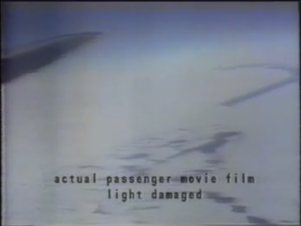
Firstly, apologies for the overall quality of the image - it has clearly undergone several conversion stages - including cine duplication, conversion to VHS via projection, conversion to digital video from VHS and heaven knows how many subsequent digital conversions before I managed to get hold of it.
That said, there's enough detail there to ascertain that it seems to have been shot at an altitude rather lower than FL180, and if that is indeed the case, the only time it can have been shot was during the descent phase. I'm not experienced enough to say for certain, but my guess would be that it was taken during the north-northeast-bound leg of the racetrack pattern (FL100) or during/just after the last 180 degree turn (approx. FL075). If that supposition is correct, then the phrase "a gap in the cloud" is something of a misnomer, because that footage shows more "gap" than "cloud" all the way down to the ground!
b. McMurdo Sound is not a "mountainous region" - it is a flat expanse of sea ice with cliffs either side. The terrain is not akin to, say, the Himalayas - or even the Alps (which are a continuous stretch of high ground for hundreds of miles). In terms of high ground, Ross Island is something of an anomaly if you compare it to the immediately surrounding area. I know it's not very scientific, but just to give you an idea, fire up Google Earth and have a look at the area while tilting the view. The McMurdo Sound route gives 24km lateral clearance from the peak of Erebus, and around 10km lateral clearance from higher ground to the east and west. If my understanding is correct, in places pilots - even ATPL crews operating heavies - experience tighter terrain clearances than that operating around Hawaii.
c. As far as "relying only on the INS for safety" goes (and again, I've heard that phrase quite a few times in relation to this subject), my feeling is that this supposition does not stand up to scrutiny. My belief is that the argument would stand if Collins and his crew had performed the circling descent such that the final turn had them more-or-less directly below the position they vacated at top of descent, which would not only infer total reliance on the INS track in terms of their position, but would also leave very little opportunity for the radar operator to warn them if they were in trouble. But the evidence is clear that this is not what happened - as stated above, their second orbit took them on a racetrack pattern which put them some 15 miles (approximately) to the north-east of their TOD position, such that they could not only descend from FL010 in more-or-less clear air, but also take visual fixes ahead of them before passing under the overcast that they knew was ahead - which was presumably their motivation for backtracking in the first place. Your opinion - which you are more than welcome to - may differ, but would you at least be willing to consider the point that if Collins and crew were as confident and reliant solely on the AINS as that argument makes out, there would have been no motivation to backtrack approx. 15 miles northeast during the descent?
2. If you are flying VFR, you do not repeatedly arm the INS. That is adding an unauthorised layer of complexity, not safety.
Breaking this point down, to the best of my knowledge, there's nothing in the VFR rules stating that NAV mode may not be used.
Furthermore, and with all due respect (i.e. Please don't take offense at the following!), my view is that this is one of those areas where experience in GA flying with a PPL (and indeed single-seat military flying experience) can actually obscure understanding - because airline/ATPL ops (particularly in large jets) are very different in a practical sense. So much time has passed since their introduction that it's sometimes easy to forget that the first generation of widebodies (B747, L1011 and DC-10) were the first widely-available airliners in the west to be more-or-less fully-automated in the sense we understand it today (The HS Trident was ahead of the curve in that respect, but it didn't sell outside of the UK and China). All of which is a long-winded way of saying that this generation of airliners was pretty much the first where it was the norm to arm the autopilot shortly after "gear-up", and rarely disengage it until final approach. In these airliners (and in the generations that followed), departure and approach procedures (along with holding patterns and the like) were more often than not flown - in the lateral sense - via the autopilot using the heading select mode - turn the knob/dial, and the aircraft will comply.
Why bring this up? Well, because - as I understand it - the circling descent and racetrack pattern were flown using this method with the autopilot active throughout. When I saw your post a couple of days ago, I did a little bit of digging with regards to the original DC-10 autoflight control panel - and far from being complex, to switch between HDG SEL mode and NAV mode is a matter of pushing a single ****on (marked INS) - and switching from NAV to HDG SEL mode is a matter of pulling out the HDG dial. The current autoflight mode can be determined by looking at the lights on the annunciator panel. The crew would have been used to this procedure as a result of having done it on almost every departure and hold/approach they'd done in the DC-10 since they did their type rating.
Apologies if I'm misunderstanding you, but I don't see how using NAV mode adds complexity in this instance.
3. Having done the above, finding yourself in a commercial jet at 2000' and not VMC, situational awareness and airmanship dictates you immediately climb to safety, not descend further to 1500'. Once that final poor decision was made, the die was cast.
Last dissection for now, and again I promise I'm simply asking you to consider what I'm saying.
a. Look at this photograph (cribbed from page 14 of W. Parsons' article, in turn taken from Capt. Vette's book)

This photo looks to have been taken during the final five minutes of flight - i.e. after the final turn back on track and therefore at some point between FL070 and FL020 (or thereabouts) - this supposition is based on the fact that it is confirmed at source to be a view to the west, looking towards the coast of Victoria Land, and appears to be taken at an altitude considerably below FL018.
If this supposition is wrong then so be it - but if it is not, I think I can be pretty confident in stating that the conditions depicted are more than sufficient to comply with the definition of VMC. The crew would have seen similar conditions as they made their final 180 to the left, and because the information on whiteout was withheld from them, they would have had no reason to expect visibility problems up ahead after turning back onto their track heading (and if worse comes to worst, MacCentre have them on radar and will warn them if things look dicey).
b. Looking at Appendix 4 of Annex D in the Chippindale report, there is little to suggest a deliberate descent from a hold at FL020 to FL015 - the profile seems more in keeping with a gradual descent to 1,500ft as invited to do so by MacCentre. If they'd been briefed on sector whiteout, it's likely that they'd have initiated an escape sooner. Be that as it may, the CVR records Collins saying "We might have to (drop) down to fifteen hundred here", but he makes no reference to visibility problems on his part at this point (the cliffs to the left and right are still visible). *Cassin* then says "Probably see further in anyway", but shorn of context we don't know what he's referring to - anyone on the flight deck trying to spot Erebus is looking to the south-east (which is where they're expecting it to be).
Here's where Chippindale's controversial solo operation on the CVR really comes into play. He has an unidentified person state "Bit thick here eh Bert", to which the voice confirmed to be F/E Malone replies "Yeah bloody oath". When Mahon visits the NTSB in Washington, their specialist tells him that he believed the first speaker to be Peter Mulgrew, and the words actually spoken to be "This Is Cape Bird". Mulgrew follows up in the next few seconds with "Ross Island there" and "Erebus should be here". This would completely change the context of F/E Malone's statement - which is important because...
c. Your statement "...finding yourself in a commercial jet ... and not VMC, situational awareness and airmanship dictates you immediately climb to safety" reflects precisely what Collins and his crew did. See above for the reasons I believe they were in VMC during the descent and the reasons they believed they were in VMC until shortly before impact. Whether his motivations were honest or not, by altering the phrase before Malone's "Yeah bloody oath", Chippindale pushes back the point at which concern was first stated by some 125 seconds - which, as I'm sure you'll agree, is an eternity in aviation terms. Even more so when you consider that "Yeah bloody oath" was said 3 minutes and 5 seconds before impact, and F/E Brooks's statement "I don't like this" (the point at which planning an escape maneouvre begins) came only 60 seconds before impact.
Here again, we come to a distinct difference between GA flying and airline ops. By the late '70s, the concept of CRM had been adopted across much of the industry (possibly spurred on post-1977 after the Tenerife disaster, in which a senior B747 Captain overruled the concerns of his junior officers, tried to take off without clearance and hit another B747 taxiing down the runway). ANZ's variant was called "crew loop", and it required the flight crew to agree on a course of action before that action was taken unless there was an immediate (and obvious) threat to safety. Had Capt. Collins acted unilaterally, he would have been in breach of that procedure - hence the heartbreaking delay - the amount of time elapsed while working out what their escape action would be.
The first point at which the flight crew become aware of the degree of danger they are actually in is the GPWS warning - seven seconds before impact (needless to say, too late).
What you are arguing about are mitigating factors - things that might (or might not) help us understand why Collins made the poor decisions he did. But it doesn't change the fact they were poor decisions.
In terms of this post, I've effectively been forced to rely on explanation and consideration - though I would suggest that it's not about "why Collins made the poor decisions he did" as much as why I don't believe any of the decisions he made were poor based on what he knew and the prevailing circumstances of the time.
However, when it comes to subjects such as the possibility that the MSAs underpinning ANZ and Chippindale's arguments may well have neither existed nor been valid in regulatory terms at the time of the accident - that's not a mitigating circumstance, that's a case of misrepresentation of flight regulations which are supposed to be sacrosanct. Or that by withholding information on sector whiteout from the Antarctic briefings, ANZ effectively rendered determination of VFR conditions unfit for purpose (and furthermore sent 12 crews down to the ice without that knowledge). NZCA had two separate and contradictory protocols for Antarctic operations filed for the best part of three years, and not once was this state of affairs reviewed.
As you said above - aviation is underpinned by rules, regulations and procedures which the competent pilot should consider immutable. What chance does a pilot stand when the regulatory body cannot be sure of which rules they are supposed to enforce?
One last thing to ponder, if you'll humour me. Approximately 10 seconds after stating an intent to climb out (16 seconds after "I don't like this") and just prior to the first GPWS warning, Collins's last call is to refuse a climbing right turn offered by Cassin - presumably because he can't see any ground detail in that direction over Cassin's shoulder (and would thus be in breach of VFR by turning right). If the supposition that Collins knowingly busted MSA, trusted solely in his INS prior to descent and took a somewhat laissez-faire approach to VMC requirements were true, why would he suddenly develop a desire to go by-the-book at that point?
|
|
|
|
| |
|
|
|
Joined: 23/01/2012
Posts: 39
|
|
|
He didn't develop a sudden desire to go-by-book. Rather, he developed a sudden desire to remain alive, because he remembered his briefing and remembered that he was told that the waypoint was at McMurdo Station and that it was at the same location during the simulator exercise and he remembered plotting it at a different location the night before but he also remembered that he hadn't checked it and he realised that Erebus might be dead ahead and that Mount Bird might be to the right - so he went left.
|
|
|
|
| |
|
|
|
Joined: 26/10/2009
Posts: 11
|
|
|
oranmore wrote
He didn't develop a sudden desire to go-by-book. Rather, he developed a sudden desire to remain alive, because he remembered his briefing and remembered that he was told that the waypoint was at McMurdo Station and that it was at the same location during the simulator exercise and he remembered plotting it at a different location the night before but he also remembered that he hadn't checked it and he realised that Erebus might be dead ahead and that Mount Bird might be to the right - so he went left.
Possibly, but the truth is we'll never really know why he hesitated to climb away before eventually deciding to turn east. Just as we'll never quite know what he meant by saying "we're 26 miles north, we'll have to climb out of this". My own guess would be that during the time Cassin was suggesting a 180 to the west, Collins was doing a quick mental stocktake of the whole situation and probably wasn't putting *that* much thought into the direction he turned. But as I say, we'll never know.
|
|
|
|
| |
|
|
|
Joined: 28/08/2015
Posts: 17
|
|
|
Gasman wrote
Possibly, but the truth is we'll never really know why he hesitated to climb away before eventually deciding to turn east. Just as we'll never quite know what he meant by saying "we're 26 miles north, we'll have to climb out of this".
Did he "decide to turn east"? As far as I can tell from the flight recorder data there was no lateral change when he pulled up and called for go-around power. I know my posts above are a bit long-winded, but as I explained in one of them there was no hesitation by Collins in deciding to climb away - it's just that the "Crew Loop" CRM procedures required the crew to agree on a course of action before following it unless they were in obvious and immediate danger (which only becomes apparent when the GPWS alarm sounds - and Collins' reaction to that is *instantaneous*, setting climb pitch and calling for TOGA power).
Obviously we can't know for certain, but regarding "we're 26 miles north, we'll have to climb out of this", my money would be on a simple statement of fact - as they go into whiteout, the ground detail either side is disappearing ahead and they don't know why. "26 miles north" is presumably a reference to their distance from the next waypoint (which they believe is Dailey Island). Deciding to climb out at this point means that they likely won't be able to subsequently re-descend to an altitude suitable for sightseeing - that aspect of the flight is now not going to happen.
@oranmore - I don't mean to be rude, but your continuing assertion that the crew was briefed direct to to the McMurdo Station TACAN simply flies in the face of the majority of the available evidence. When giving evidence to the Commission; of the pilots who gave the briefing, Capt. Johnson stuck rigidly to the company line (i.e. track was over Erebus to TACAN, MSAs were clearly given). Capt. Wilson initially presented a similar line, but at the end he acknowledged that he was aware of several flights going lower than the MSAs*. Of the pilots who *attended* the briefing, all of them stated - categorically and without hesitation - that the briefed track was down the Sound to Dailey Island before a left turn to McMurdo.
In particular, Capt. Simpson (who, it has been noted, was considered by his colleagues to be more of a company than a union man in most circumstances) in his testimony to the Commission came as close as he dared** to saying that Wilson had embroidered his evidence and testimony with extra detail which he did not himself recall, and that Johnson's evidence misrepresented the content of the briefing entirely in terms of his own recollection.
* - The "Verdict...", "...Papers" and "Daughters..." books on Erebus contain an interesting footnote to Wilson's evidence and testimony. While Johnson's written evidence and testimony followed the company line completely as stated above, Mahon noticed that the last two pages of Wilson's submitted evidence appeared to have been written on a different typewriter to the preceding pages, and it just so happened that these last pages contained Wilson's admission that he knew of previous flights going lower than 16,000ft. This raises some intriguing questions and possibilities to say the least - changing his submission at the last implies that he wasn't completely comfortable with the company's position, but neither could he entirely go against it (and in doing so risk his career) - so he ended up taking a third option to some degree by steering a course down the middle.
** - Simpson was a senior Captain earmarked for management, so to go against the company line in the way he did was actually extraordinarily brave of him. The question arises - if the company's statements regarding the MSAs and using the TACAN as the waypoint were true, then what would motivate a loyal company man with significant career advancement opportunities on the cards to state otherwise and risk losing them?
|
|
|
|
| |